


Sea level rise (SLR) is a major consequence of climate change. The densely populated U.S. East Coast and the Gulf of Mexico coast are vulnerable to SLR and extreme events. In the past six years, for example, major hurricanes and associated storm surges have caused significant and catastrophic coastal flooding and socioeconomic damages. Studying factors behind the increased coastal vulnerability, particularly the role of SLR in extreme events, is therefore urgently needed. With the advance of sea level observations and modeling, progress has been made recently so that SLR at different locations and its time-evolving behaviors can be better explained and attributed.
In a new Journal of Climate article, author Jianjun Yin analyzes observational and modeling data of sea level and its components, atmospheric pressure and winds, and ocean circulation in the North Atlantic.
It was found that both the century-long tide gauge data and the more recent altimetry data reveal a rapid decadal acceleration of SLR during 2010-2022 along the U.S. East Coast and the Gulf of Mexico coast, with the most notable on the Southeast and Gulf Coasts. Data suggests that this SLR acceleration is largely due to a lagged response to the observed slowdown of the Atlantic Meridional Overturning Circulation in 2009-2010. In the North Atlantic, the response is characterized by a large-scale pattern of contrast changes in dynamic sea level between the eastern subpolar gyre and the U.S. Southeast and Gulf Coasts. The latest global climate model generally captures this observed pattern and projects that further increase in greenhouse-gas forcing will modify it over the 21st century. The faster SLR on the Southeast and Gulf Coasts, at a rate of more than 10 mm/year during 2010-2022, coincided with active and record-breaking North Atlantic hurricane seasons in recent years. As a consequence, the elevated storm surge intensified coastal flooding and damages particularly on the Gulf Coast.
“While SLR was thought as a slow and gradual process, our results show that ocean dynamics can change regional sea level rapidly, leaving less time for the coastal communities to mitigate and adapt,” said Jianjun Yin, lead researcher and Professor at the University of Arizona.
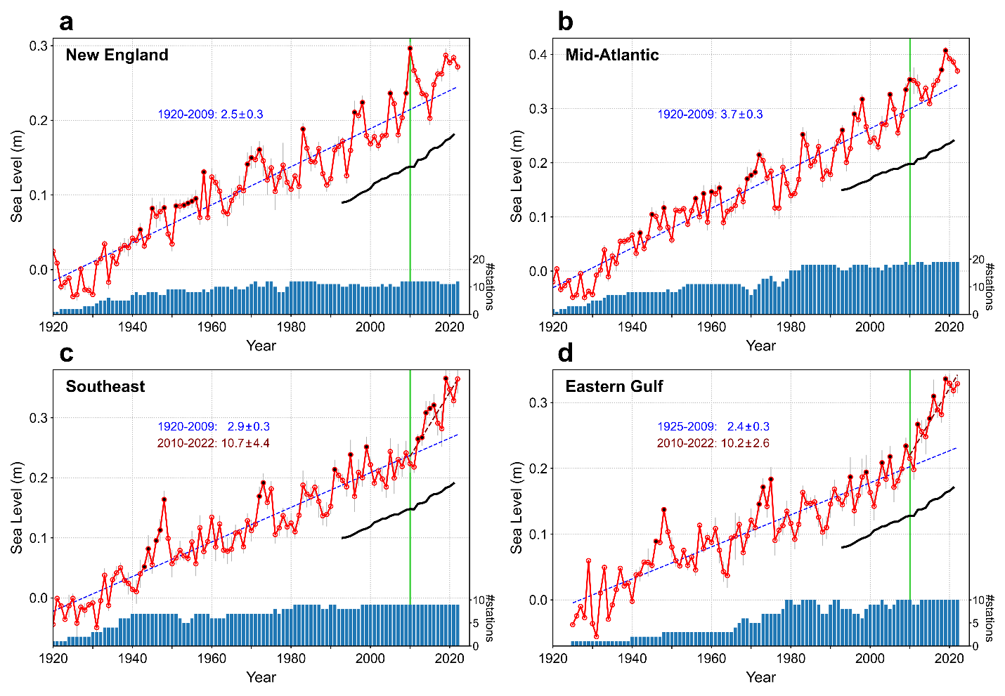
SLR along the U.S. East and Gulf Coasts from the century-long tide gauge data (1920-2022). (a) New England; (b) Mid-Atlantic; (c) Southeast; and (d) Eastern Gulf. The red curves are the mean of the tide gauge data in the same region
relative to the period of 1920-1940. The number of tide gauge stations used for calculating the regional mean is shown by the blue bars at the bottom of each panel. The black curve is the global mean SLR from altimetry. The linear SLR rates are in mm/year.
The author notes that if the 2009-2010 AMOC slowdown event turns out to be a part of a long-term weakening trend, as projected by climate models under greenhouse-gas forcing, sea levels along the Southeast and Gulf Coasts may stay high in the next years, but the high rise rates may taper off in the next decade. Additionally, in a warming climate, these irregular sea level behaviors in each decade are valuable to detect the increasing anthropogenic influence on sea level and ocean circulation from their background variability.
This study was partially funded by the MAPP program.
Read the full paper here.