


El Niño and La Niña are two opposing climate patterns of the El Niño-Southern Oscillation (ENSO), across the tropical Pacific. These climate patterns can shift back and forth irregularly every two to seven years, disrupting the large-scale air movements in the tropics, and impacting global weather patterns. Though El Niño and La Niña events show a wide range of durations over the historical record, long-range forecasts of the duration of ENSO events have, however, received much less attention, with only a few case studies focused on multi-year La Niña events and a single initialization month. Since the duration of ENSO events could affect the length of their associated climate and socioeconomic impacts, it’s important to have accurate predictions of ENSO event durations with the longest lead times possible.
In a new Journal of Climate, authors Xian WU, Yuko M. Okumura, Clara Deser, and Pedro N. DiNezi, use multiyear ensemble forecasts conducted with the Community Earth System Model, version 1 (CESM1) to explore the predictability of El Niño and La Niña event durations. The 10–40 member forecasts are initialized with observed oceanic conditions on March 1, June 1, and November 1 of each year during 1954–2015. It was found that the CESM1 predicts the duration of individual El Niño and La Niña events with lead times ranging from 6 to 25 months, and forecasts initialized in November, near the first peak of El Niño or La Niña, can skillfully predict whether the event continues through the second year with 1-year lead time. In addition, the occurrence of multiyear La Niña events can be predicted even earlier with lead times up to 25 months, especially when they are preceded by strong El Niño. The high predictability of event duration indicates the potential for extending 12-month operational forecasts of El Niño and La Niña events by one additional year.
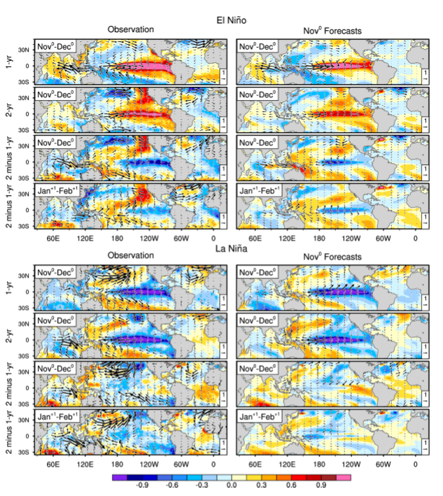
Maps of SST (°C; shading) and surface wind anomalies (m/s; vectors) composited for (top four) El Niño and (bottom four) La Niña based on (left) observations and (right) ensemble mean forecasts initialized in Nov0. For El Niño and La Niña maps, top row shows results for 1-yr events, second row for 2-yr events, and third row for their difference (2-yr minus 1-yr), all during Nov-Dec. Bottom row shows the difference between 2-yr and 1-yr events during Jan+1-Feb+1.
The authors note that further research is needed to explore the model and seasonal dependencies of the predictability of ENSO event duration, but that this study highlights the benefit of extending the forecasts even for selected models and selected initialization months. Multiyear ENSO forecasts will provide a new basis for predictions of prolonged climate anomalies, such as persistent drought in the southern US and widespread flooding in Australia, during multiyear La Niña events.
Funding for this project was provided in part by the NOAA Climate Program Office, MAPP program and National Integrated Drought Information System.
Read the full paper here
———————————————————————————————–
About MAPP
The Modeling, Analysis, Predictions, and Projections (MAPP) Program is a competitive research program in NOAA Research’s Climate Program Office. MAPP’s mission is to enhance the Nation’s and NOAA’s capability to understand, predict, and project variability and long-term changes in Earth’s system and mitigate human and economic impacts. To achieve its mission, MAPP supports foundational research, transition of research to applications, and engagement across other parts of NOAA, among partner agencies, and with the external research community. MAPP plays a crucial role in enabling national preparedness for extreme events like drought and longer-term climate changes. For more information, please visit www.cpo.noaa.gov/MAPP.
About NIDIS
The National Integrated Drought Information System (NIDIS) program was authorized by Congress in 2006 (Public Law 109-430) with an interagency mandate to coordinate and integrate drought research, building upon existing federal, tribal, state, and local partnerships in support of creating a national drought early warning information system. For more information, please visit https://www.drought.gov/drought/.