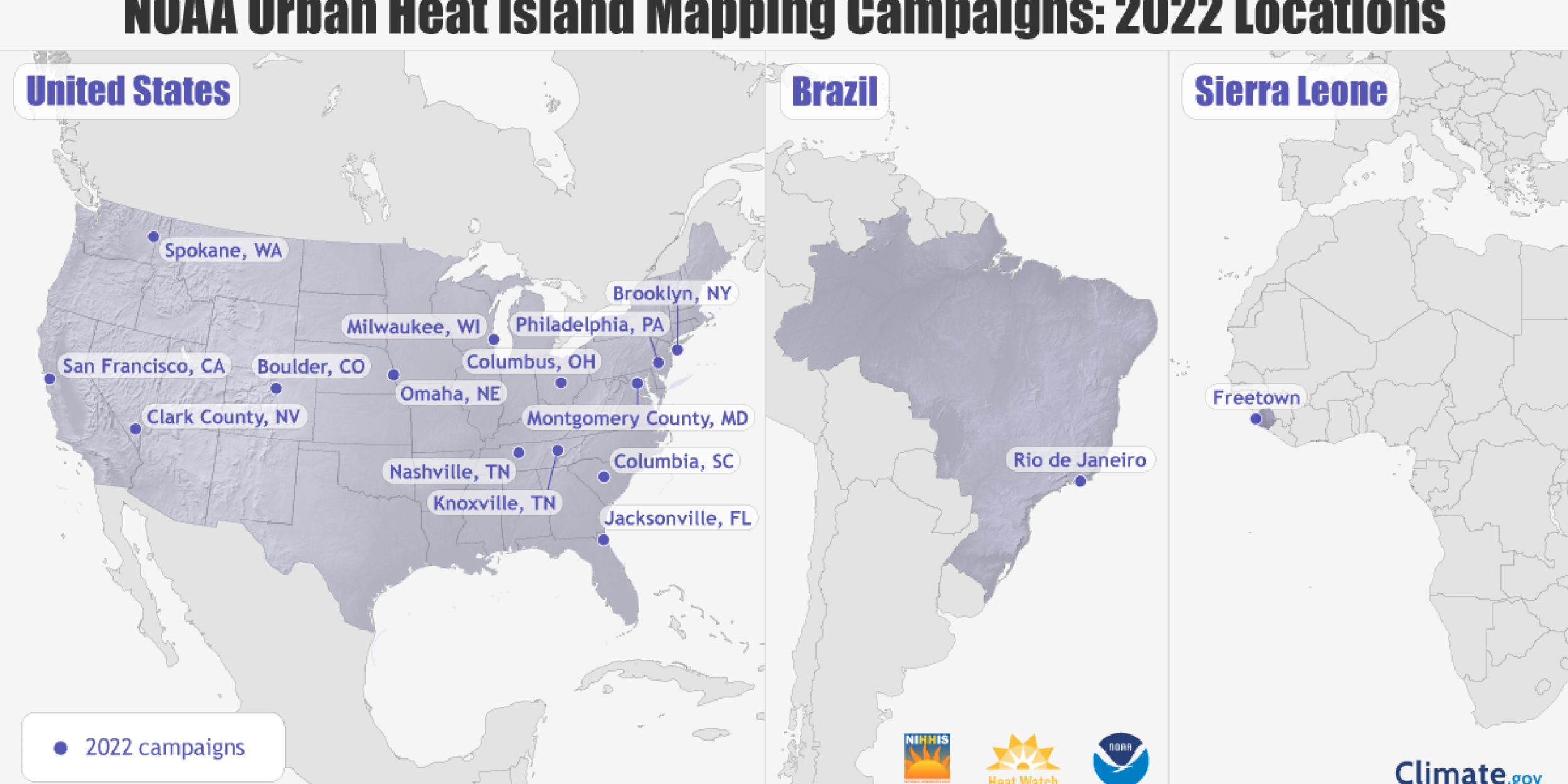
On April 26th during the opening remarks for the National Integrated Heat Health Information System (NIHHIS) National Meeting, NOAA Administrator Dr. Richard Spinrad announced that NOAA and community partners will be mapping heat inequities in 14 communities across the country this summer, and two international cities.
“Our nation faces a climate crisis that has exacerbated inequities for the low-income and communities of color,” said NOAA Administrator Rick Spinrad, Ph.D. “NOAA is helping communities measure their hottest places so that they can use this information to develop strategies to reduce the dangerous effects of heat and help us create a Climate Ready Nation that is resilient in a changing world.”
Since 2017, NOAA has funded CAPA Strategies LLC to provide science support for citizen science, community based campaigns to map the hottest parts of communities through the NIHHIS-CAPA Urban Heat Island Mapping Campaign program. Using heat sensors mounted on their own cars or bikes, volunteer citizen scientists, led by a team of local partners in each city, traverse their neighborhoods in the morning, afternoon, and evening. With support from the National Weather Service Weather Prediction Center (WPC) and local Weather Forecast Offices (WFOs), communities are provided forecasts in advance so that they are mapping their neighborhoods on the hottest day. NOAA has provided funding for 35 campaigns, and support for 69 total campaigns.
The communities to be mapped in 2022 include Boulder, Colorado; Clark County, Nevada, which includes Las Vegas; Columbia, South Carolina; Columbus, Ohio; Jacksonville, Florida; Knoxville and Nashville, Tennessee; Milwaukee, Wisconsin; Montgomery County, Maryland; Omaha, Nebraska; Spokane, Washington; and Philadelphia. Brooklyn, New York and San Francisco, originally part of the 2021 campaign year, will also be completing their mapping campaigns this summer. In addition, NOAA is working with local groups on international campaigns in Freetown, Sierra Leone and Rio de Janeiro, Brazil.
The 2022 heat mapping campaigns will also feature new, NOAA-funded instruments to better characterize urban climate and health hazards. Columbus, Ohio, and Philadelphia will use mobile air quality monitors to develop an understanding of the related impacts of heat and air quality. Clark County, Nevada, and Columbia, South Carolina, will install stationary temperature and humidity sensors to provide more information for decision-making through monitoring the urban heat island effect over the length of the summer. Additionally, the NIHHIS-CAPA UHI mapping campaign is part of the Biden Administration’s Justice40 initiative.
Read the official press release »
Read more about the NIHHIS National Meeting proceedings »
For more information, contact Morgan Zabow.


