Official websites use .gov
A .gov website belongs to an official government organization in the United States.

Secure .gov websites use HTTPS
A lock ( ) or https:// means you’ve safely connected to the .gov website. Share sensitive information only on official, secure websites.

Events/Webinars

Applicant Resources
at a Glance

NOAA’s Climate Program Office awards over $1 million to improve climate information, services for extreme heat resilience

Five new projects will build on outcomes from NOAA’s community-led urban heat mapping campaigns

NOAA’s Climate Program Office (CPO) is pleased to announce $1.25 million for five new projects that will support decision making in neighborhoods grappling with inequitably distributed impacts from the deadliest weather-related risk in the United States—extreme heat. 

This Washington, D.C. map reveals a range of temperatures on the afternoon of Aug. 28, 2018, from a low of 85 degrees F to a high of 102 degrees F. Temperature data are colored in shades of blue (coolest half of the day's temperature range) to red (warmest half). Credit: NOAA Climate.gov based on data courtesy of Portland State University.
This Washington, D.C. map reveals a range of temperatures on the afternoon of Aug. 28, 2018, from a low of 85 degrees F to a high of 102 degrees F. Temperature data are colored in shades of blue (coolest half of the day’s temperature range) to red (warmest half). Credit: NOAA Climate.gov based on data courtesy of Portland State University.

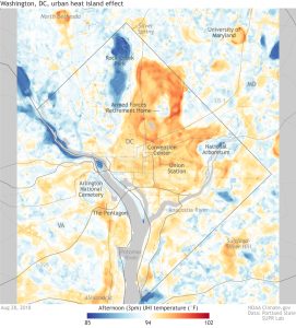
As climate change makes heat waves more frequent and longer lasting, heat-related health impacts are rising in the United States with over 700 deaths and tens of thousands of emergency room visits each year. Much of this impact is felt in cities where roads and buildings absorb and radiate more heat than grassy, natural landscapes. And for the growing number of city dwellers, the experience of extreme heat can vary across neighborhoods by as much as 20°F. 

Though cities are adapting to these changes and mitigating urban heat, they need tools and resources to help them produce the most effective and efficient solutions tailored to their needs. With this in mind, the new projects will improve climate information and services to help state and local governments take action toward equitable urban heat resilience in both the near- and long-term. 

“Even within the same community, some neighborhoods are experiencing much higher temperatures than others,” said Hunter Jones, lead of CPO’s Extreme Heat Risk Team. “These projects will address research gaps to help cities understand what factors are contributing to urban heat disparities and evaluate science-based interventions to design safer cities and protect communities.”

The five new projects will build on outcomes from four years of community science field campaigns—supported by NOAA’s National Integrated Heat Health Information System (NIHHIS), CPO’s Communication, Education, and Engagement (CEE) Division, communities, and partners—that have produced detailed maps of the hottest neighborhoods in cities, showing where action is needed to save lives. The mapping campaigns have provided critical high-resolution temperature information, but cities need further technical capacity to integrate the results with additional data and existing planning efforts to develop targeted and equitable heat mitigation strategies. 

Cities are adapting to increasingly hot climates and implementing strategies like green roofs and tree planting programs, but they need more climate information to produce the most effective, efficient solutions tailored to their needs. Image credit: smallchan; Dennis Schroeder / NREL; Lawrence Berkeley National Laboratory/Roy Kaltschmidt; Arlington County, VA used under a Creative Commons license.

Over the next two years, each project will combine data and maps from previous campaigns with new experimental methods and research to advance urban heat risk reduction.

Anticipated outcomes include:

  • scorecard for evaluating a city’s heat resilience policies and plans across communities, 
  • a new tool for identifying optimal heat mitigation strategies at the city level,
  • new data and information on extreme heat exposure risk in small cities and rural settlements across Vermont, 
  • an improved modeling framework for forecasting urban heat and simulating heat mitigation scenarios for cities near large water bodies, and 
  • comprehensive information package to provide everything from dynamic heat maps to vetted intervention options. 

“All of the projects will help improve what we know about urban heat and the factors affecting it, and inform how we can take equitable actions to reduce heat risk for every resident of our communities,” said Jones. 

The projects were selected through a competitive review process and represent those best positioned to meet the goals of CPO’s Extreme Heat Risk Team—one of four initial climate risk areas that CPO is targeting through its Climate Risk Areas Initiative launched last summer. Through the Extreme Heat Risk Team, CPO is empowering communities to monitor, understand, and respond to their own local heat exposures.

Learn more about the five new projects.

Desert Research Institute and Houston Advanced Research Center
Funding: $207,329
Contact: Detra Page (detra.page@dri.edu) and Kacey Wilkins (kwilkins@harcresearch.org)

Urban heat for many cities near large water bodies, such as seas or lakes, is influenced by land and sea breezes that aren’t captured well in models, causing errors in heat forecasts. With that in mind, this project will develop a modeling framework for urban heat in coastal cities and analyze multiple datasets, including the city’s data from the NOAA community-led urban heat mapping campaign, using machine learning to better predict what will occur.

The project team will use the modeling framework to quantify how urban temperature will be impacted by different urban heat mitigation strategies contemplated in the Houston’s Climate Adaptation Plan (2020) and Resilient Houston (2020) reports. The Greater Houston area will serve as a testbed for the project and modeling framework which could be applied to other cities influenced by large water bodies both in the nation and worldwide. The project team will work closely with the Houston/Galveston National Weather Service Forecast Office and the City of Houston Sustainability and Resilience Office.

Read the announcement

University of Vermont
Funding: $300,000
Contact: Geeda Searfoorce (geeda.searfoorce@uvm.edu)

Though big cities usually get most of the attention when it comes to urban heat, every community with a village, town or city center likely has the built infrastructure that contributes to the urban heat island effect—where developed areas are warmer than their rural surroundings, particularly at night. For instance, the highest temperatures associated with this summer’s recent extreme heat wave out west occurred in the small community of Lytton, Canada, which has a population of 250. This project led by the University of Vermont, in partnership with groups such as the Vermont Health Department, Vermont Emergency Management, Efficiency Vermont, and NOAA’s National Weather Service, will characterize the heat signature in small and rural communities across the state of Vermont that are often left out of urban heat research. In particular, the research team will identify where people all across Vermont are exposed to excessive heat produced by transportation infrastructure, map areas of vulnerability (where there is higher heat and populations at greater risk of adverse health impacts from heat exposure), and help state and municipal agencies target solutions to the places and people that most need them. In addition to raising awareness about this issue in local communities, the findings of this project will help state and local partners better target programs and interventions to help communities and individuals adapt to future heat waves.

Read the announcement

The University of Arizona
Funding: $147,474
Contact: Ladd Keith (ladd@arizona.edu)

While many states and local governments are developing strategies to address urban heat, there is little collaboration within communities. The lack of coordination on urban heat resilience can result in ineffective heat mitigation, or worse, contribute to urban heat in areas of highest risk. To help bridge these disparate efforts, University of Arizona researchers are leading an effort called Plan Integration for Resilience Scorecard for Heat, or PIRSH. The team’s research will build from a method recently adopted by the American Planning Association (APA) as a national standard and resource for building local capacity to integrate resilience planning across sectors, which has been successfully applied to flood planning.

PIRSH will help communities systematically evaluate their current heat mitigation strategies across relevant plans, compare the combined effect of those strategies with heat risk data (including data from NOAA’s community-led urban heat mapping campaigns), and identify opportunities for improved planning. This will help communities bring together traditionally siloed disciplines and align their urban heat resilience efforts to reduce the negative health, economic, and environmental impacts of heat. PIRSH has been piloted in Tucson, Arizona and will now be expanded to five other geographically distinct U.S. cities: Baltimore, Boston, Fort Lauderdale, Houston and Seattle. Ultimately, the team will work with APA to disseminate the PIRSH methodology to over 46,000 APA members across the U.S. and beyond.

Read the announcement

Johns Hopkins University and RAND Corporation
Funding: $298,622
Contact: Kait Howard (kehoward@jhu.edu)

Communities and city agencies have multiple priorities and constraints that need to be considered when designing and implementing heat mitigation plans: indoor versus outdoor temperature, shade on the street versus access to park oases, minimizing heat-related deaths versus minimizing heat-associated childhood asthma. Sometimes these objectives point to the same solution, but often they do not. Cities need decision tools that help identify optimal city-scale heat mitigation strategies for the hot spots mapped in the urban heat island campaigns.

This project will develop an optimization model called City-HEAT (City Heat Equity Adaptation Tool), adapted from a model created through a NOAA Climate Program Office Mid-Atlantic Regional Integrated Sciences and Assessments (RISA) project. City-HEAT will assess urban heat adaptation policy interventions and strategies based on their performance across multiple objectives and a range of future climate, demographic, and socio-economic scenarios. The model will consider both long-term heat interventions like green infrastructure investment as well as short-term responses like cooling center issuance.

Results from the City-HEAT simulations can then be mapped to vulnerable neighborhoods identified through NOAA’s community-led urban heat mapping campaigns. City-HEAT will provide stakeholders and decision makers with a range of intervention options designed to meet stated heat mitigation objectives at neighborhood scale.

There’s no one single “one size fits all” approach to reduce heat inequity. Instead, cities need tools like City-HEAT that put the power of urban heat science in the hands of communities, allowing them to make the heat mitigation decisions that best meet their needs. The project will focus on a single city but, in partnership with the Mid-Atlantic RISA team and The Nature Conservancy, will also test how well City-HEAT can be applied to other cities.

The University of Texas at Austin
Funding: $296,477
Contact: Anton Caputo (anton.caputo@jsg.utexas.edu) and Monica Kortsha (mkortsha@jsg.utexas.edu)

The University of Texas at Austin is partnering with the City of Austin, community groups and East Austin residents to find out where hot temperatures are affecting people the most – and proposing solutions to cool these places down. The project builds on the city’s heat map created during NOAA’s community-led urban heat mapping campaigns last year from measurements collected by a team of 17 volunteers.

The two-year project has three main goals: creating dynamic heat maps that depict how people experience the heat alongside actual temperature measurements; using those maps to develop strategies to cool down temperature hot spots; and, finally, presenting the data and potential solutions to community members and city decision makers.

By using a combination of satellite data, on-the-ground sensors and computer models, the heat maps will be able to give a view of the temperature landscape that can go from all of Central Texas to a single street. To make sure temperature readings and community experiences of heat are aligned, the project team will incorporate resident input from the very beginning. The research team will also investigate how different intervention options will affect local temperatures in coming decades to ensure that any proposed solutions hold up over time.

In addition to presenting findings to the Austin City Council and other local decision makers, the researchers will share what they learned with international colleagues through webinars and workshops so that others can benefit from the project outcomes.

Read the announcement

For more information, please contact Hunter Jones, NOAA Climate Program Office Extreme Heat Risk Initiative competition manager at hunter.jones@noaa.gov.

Funding Opportunities News and Events

CPO Awards Announcement banner with rain, drought, and satellite in space
Scroll to Top