Drought is an extreme weather event that impacts all sectors of the economy. Estimates of water budget components from land-surface models (LSMs) are routinely used in drought monitoring and forecasting environments. In particular, the North American Land Data Assimilation System (NLDAS) runs four separate LSMs driven with high-quality meteorological data, including gauge-based precipitation analysis and bias-corrected radiation. The near-real-time NLDAS drought monitor provides several indices of drought estimates based on anomalies and percentiles of precipitation, soil moisture, streamflow, snow, and evapotranspiration. However, most near-real-time LDAS environments only include limited hydrological observations, such as climatologically-based maps or look-up tables of vegetation states such as the green vegetation fraction (GVF) and/or the Leaf Area Index (LAI). This will in turn limit the representation of interannual variations of the evapotranspiration and the land water and energy states, which in turn, limits their ability to simulate rapidly-emerging drought conditions.
In a new Journal of Hydrometeorology article, authors David Mocko, Sujay Kumar, Christa Peters-Lidard, and Shugong Wang use the Noah-MP LSM, which simulates water and energy fluxes and states, which are transformed into drought categories using percentiles over the continental U.S. from 1979 to 2017. In addition, Leaf Area Index (LAI) observations are assimilated into the dynamic vegetation scheme of Noah-MP. A weekly operational drought monitor (the U.S. Drought Monitor) is used for the evaluation.
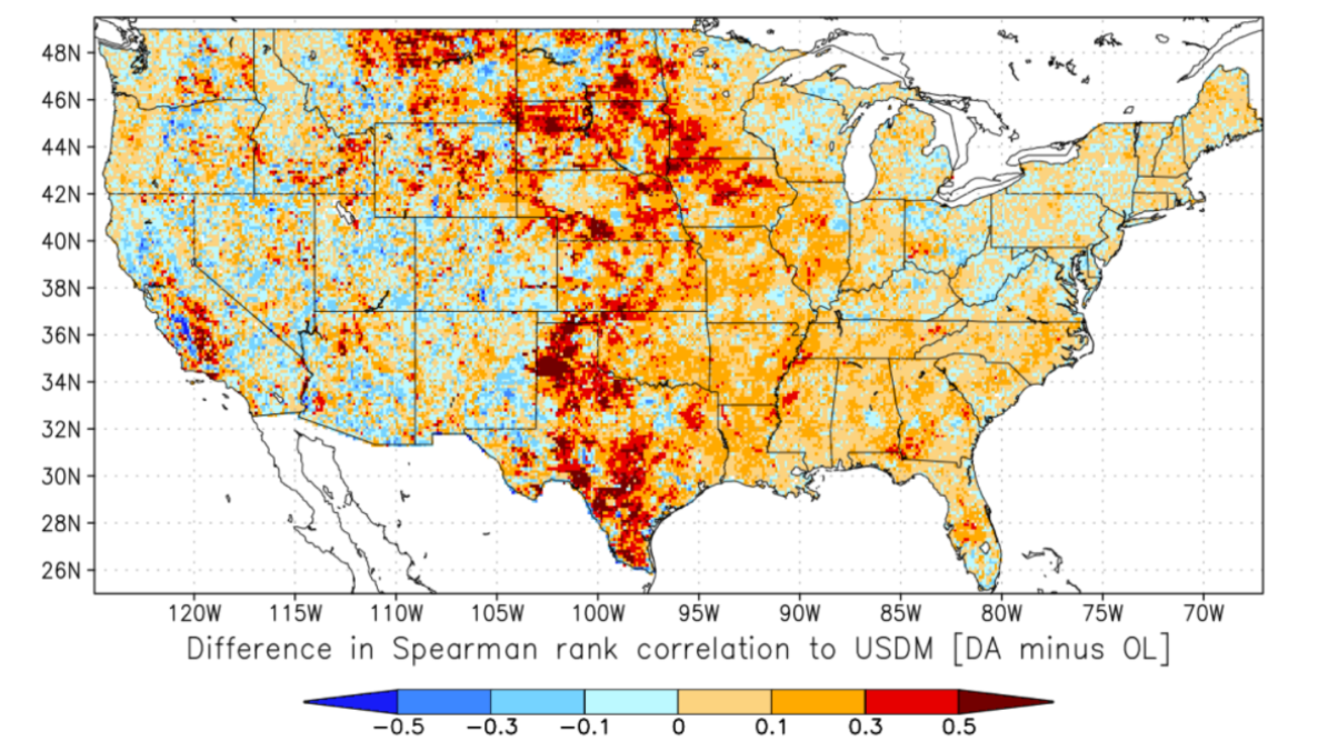
It was found that LAI assimilation into Noah-MP’s dynamic vegetation scheme improves the model’s ability to represent drought, particularly over cropland areas. In addition, the LAI assimilation improves the simulation of the drought category, detection of drought conditions, and reduces the instances of drought false alarms. The assimilation of LAI in these locations not only corrects model errors in the simulation of vegetation, but can help represent unmodeled physical processes such as irrigation towards improved simulation of agricultural drought.


Difference in the Spearman rank correlation of drought intensity estimates compared to the USDM data for 18 years (2000–2017), shown as the correlation of the DA run to the USDM minus the correlation of the OL run to the USDM. For both model runs, percentiles of the top 1-m soil moisture are used to calculate the drought category. Warm colors (orange to red) show areas where there is improved correlation to the USDM due to LAI assimilation.
This study was partially funded by the MAPP program in collaboration with NIDIS.
Read the full paper here
———————————————————————————————–
About MAPP
The Modeling, Analysis, Predictions, and Projections (MAPP) Program is a competitive research program in NOAA Research’s Climate Program Office. MAPP’s mission is to enhance the Nation’s and NOAA’s capability to understand, predict, and project variability and long-term changes in Earth’s system and mitigate human and economic impacts. To achieve its mission, MAPP supports foundational research, transition of research to applications, and engagement across other parts of NOAA, among partner agencies, and with the external research community. MAPP plays a crucial role in enabling national preparedness for extreme events like drought and longer-term climate changes. For more information, please visit www.cpo.noaa.gov/MAPP.


