Tornados are one of nature’s most 

In a recent paper published in Environmental Research Letters, scientists with NOAA labs and the University of Miami have identified that the dominant spring flavors of El Niño-Southern Oscillation (ENSO) could be used, in conjunction with the leading sea surface temperature pattern in the North Atlantic, to advance capabilities for developing a skillful, long-range outlook for tornado outbreaks across the U.S..
“This is the first study to show that the most frequently occurring spring sea surface temperature patterns in the tropical Pacific and North Atlantic are linked to distinctive spatial patterns of the probability of U.S. regional tornado outbreaks,” said lead author Dr. Sang-Ki Lee, Ph.D., an oceanographer at NOAA’s Atlantic Oceanographic and Meteorological Laboratory (AOML).
Researchers at NOAA labs and the Cooperative Institute for Marine and Atmospheric Studies at the University of Miami investigated the spatial patterns of springtime U.S. regional tornado outbreaks from 1950-2014 and their connection to spring ENSO variations (or flavors). ENSO, or the El Niño-La Niña cycle, is a natural climate pattern in the Pacific Ocean. During an El Niño event, warm sea surface temperatures spread across the eastern tropical Pacific. In a La Niña year, the opposite happens: Cool sea surface temperatures dominate in the eastern tropical Pacific. These temperature shifts have a ripple effect on large-scale atmospheric processes conducive to tornado outbreaks across the U.S.
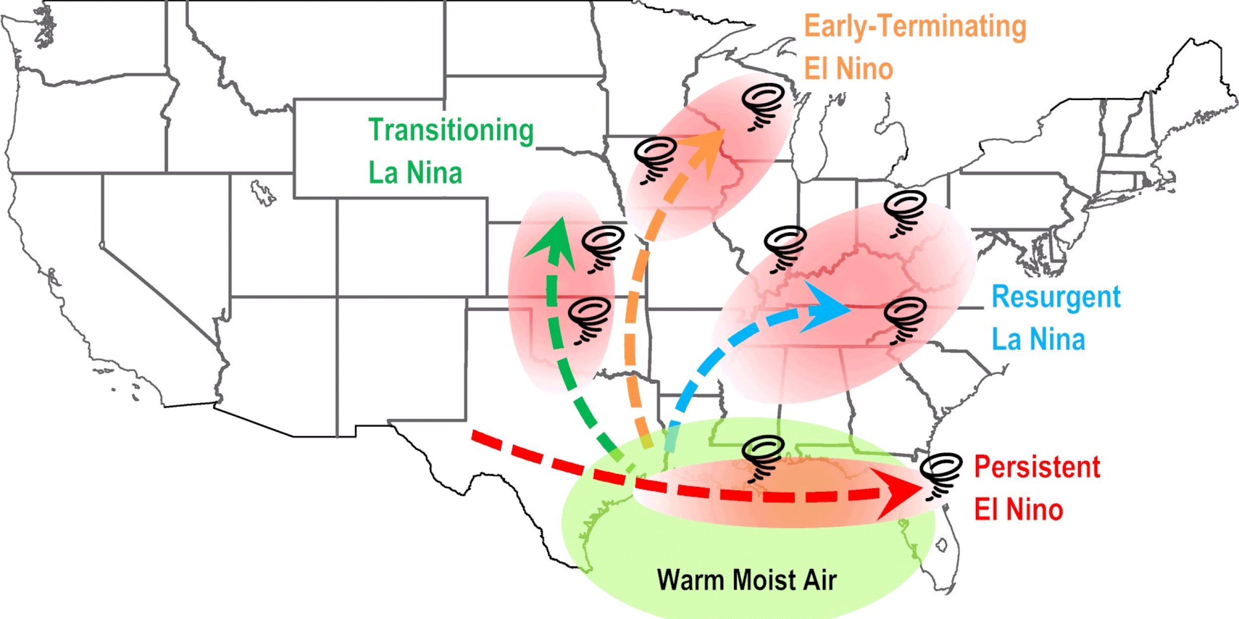
The researchers focused on four variations of ENSO events: strong winter events that persist well into spring, characterized by warm and moist upper-level air, and weak events that dissipate soon after their winter peak (See figure below). They found that weak El Niños led to tornado outbreaks in May throughout the Upper Midwest, while strong El Niños led to outbreaks in February across Central Florida and the Gulf Coast. In contrast, weak La Niñas led to April outbreaks throughout the South, particularly in Oklahoma and Kansas, while strong La Niñas, characterized by colder and drier upper-level air, led to April outbreaks along the Ohio Valley and in the Southeast and Upper Midwest.


The results suggest that each of the four dominant spring ENSO flavors is linked to distinct and significant U.S. regional patterns of outbreak probability. The strongest tornado connection was with strong, persistent La Niñas, consistent with the Super Outbreak of 1974 and the record-shattering outbreaks of 2011, both of which occurred during strong La Niñas.
The authors also report that the so-called North Atlantic sea surface temperature tripole, the leading pattern of sea surface temperature variability in the North Atlantic, is potentially tied to regional outbreaks. This link builds off of previous studies that have suggested springtime sea surface temperature patterns that typically occur following the winter peak of La Niña could lead to a tornado outbreak in the U.S.
Their continuing research aims at incorporating the spring ENSO state and the North Atlantic sea surface temperature variability into a forecast model with the goal of predicting the likelihood of U.S. tornado outbreaks one to three months in advance. Although a seasonal outlook cannot pinpoint exactly when, where and how many tornadoes may strike, it may be able to predict which regions are more likely to experience widespread tornado outbreaks based on the current climate conditions. By extending NOAA’s ability to predict tornado outbreaks, federal, state, and local agencies can plan early and pre-position resources to better prepare for emergency response. Strategic early emergency preparedness planning can save resources and potentially lives.
It is important to remember that a regional tornado outbreak may occur in any season and almost anywhere in the U.S. regardless of ENSO state. Even during an overall quiet season, one outbreak event could cause significant loss of life and property. Therefore, communities routinely exposed to severe weather systems should be ready for every severe weather season regardless of what a seasonal outlook may predict.
This research was funded in part by the Modeling, Analysis, Predictions, and Projections (MAPP) program, part of NOAA’s Climate Program Office in the Office of Oceanic and Atmospheric Research, and NOAA’s Climate Prediction Center (CPC) and Atlantic Oceanographic and Meteorological Laboratory (AOML), working in collaboration with the Geophysical Fluid Dynamics Laboratory (GFDL).
To read the research online, go to Environmental Research Letters
For more information, see image and story at Climate.gov


