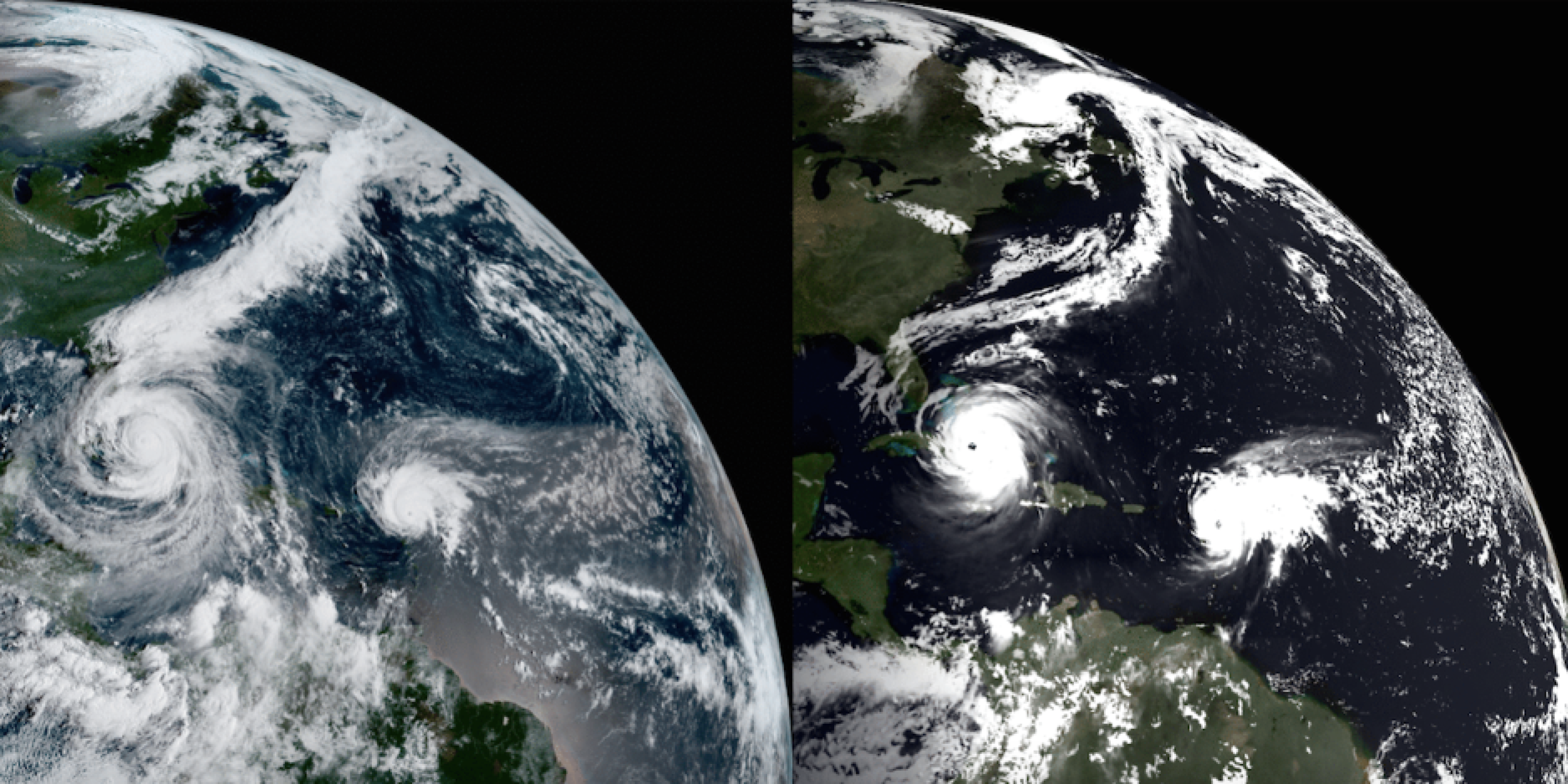

Snapshot of the performance of the FV3-GFS (8.5-km horizontal grid spacing; 91 vertical levels) for Irma. On the left is the 00Z 10 Sept. GOES-16 satellite image; on the right is the 6-day model forecast of reflected solar flux at the top of the atmosphere, verifying at the same time. Figure from GFDL.
The NOAA CPO Modeling, Analysis, Predictions, and Projections (MAPP) program hosted a webinar on research on the topic of Harvey and Irma: Prediction Across Timescales on Thursday, September 28, 2017. The announcement is provided below.
| Date/Time | Title & Presenters |
|
September 28, 2017 12:00 PM – 2:00 PM ET |
Harvey & Irma, Part Two: Prediction Across Timescales |
| Speakers and Topics | Xianan Jiang (UCLA) Extended-range predictability of hurricane genesis in a high-resolution global coupled model system S. J. Lin (NOAA/OAR Geophysical Fluid Dynamics Laboratory) Kathy Pegion (GMU/COLA), Ben Kirtman (U. Miami, RSMAS), the SubX Team Gerry Bell (NOAA/NWS Climate Prediction Center) |
| Remote Access |
To view the slideshow: |
| Watch Webcast |
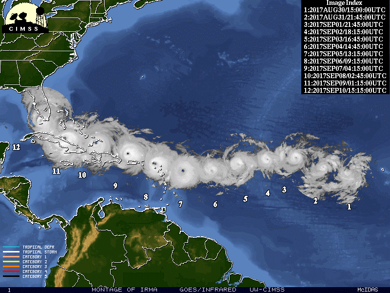

Composite satellite of the lifecycle of TC Irma (30 Aug – 10 Sep). Figure from CIMSS.
ABSTRACTS:
Xianan Jiang – Motivated by increasing demand in the community for extended-range prediction of weather extremes, predictability of global tropical cyclogenesis is investigated based on a recently updated global high-resolution coupled model system at GFDL. While encouraging beyond-weather prediction skill (~11 days) is illustrated for selected hurricanes, limited cyclogenesis prediction skill in general is found for tropical cyclogenesis over global oceans during 11 years based on this model, particularly over the North Atlantic (NA). It is further suggested that tropical storms with relatively higher genesis skill are closely linked to local MJO and convectively coupled equatorial wave (CCEW) activities, confirming critical role of the MJO and CCEWs for extended-range prediction of tropical cyclogenesis. Over the NA, where the MJO influences are relatively weak, more predictable cyclogenesis is largely found over a southeast-northwestward belt from the West Africa coast to Caribbean Seas, in accord with local higher predictability of large-scale factors, including low-level relative vorticity, mid-level humidity, and vertical zonal wind shear. In contrast, poor cyclogenesis skill is found over the extratropical NA, where the large-scale factors exhibit low predictability due to extratropical influences.
Shian-Jiann Lin – Up to date long term (2015-2017) statistics on hurricane track and intensity errors from the 13-km FV3-powered GFS will be presented. For the past two seasons (2015-2016), the track errors are slightly lower than the operational GFS. However, there is a significant improvement in the intensity prediction. Even at the relatively low 13-km resolution, the intensity errors are on par with the best intensity model, the HWRF. For the 2017 hurricane season, the FV3-GFS significantly outperformed the operational GFS, particularly for hurricane Harvey. Throughout the 2107 hurricane season, it is clear that a hurricane prediction system capable of long-range predictions would bring significant benefit to the society. We present a vision for the development and ultimately the transition to operation (R2O) of a long-range (from 5-day to S2S) hurricane prediction system, which is based on past and present research on improving MJO simulation in a GFDL model built for hurricane seasonal predictions (GFDL HiRAM, Chen and Lin 2011). A two-way nested global-to-regional FV3-GFS with 3-km resolution over the entire Atlantic basin has also been running experimentally in real-time. For hurricane Harvey, the nested grid version of FV3-GFS is shown to be capable of rapid intensification, producing heavy precipitation over Houston area 5 days in advance, which demonstrated the utility of the global-to-regional approach for long-range hurricane predictions.
Kathy Pegion (Co-authors: Ben Kirtman and the SubX Team) – The Subseasonal Experiment (SubX) is a NOAA/Climate Testbed project focused on subseasonal predictability and predictions. Seven global models are producing seventeen years of ensemble retrospective forecasts initialized weekly to investigate subseasonal prediction and predictability. Additionally, this project began producing real-time predictions in support of the NOAA/NWS Climate Prediction Center as guidance for their week-3/4 outlooks in July 2017. This presentation will provide an overview of the project and a presentation of real-time forecasts for weeks 1-4 during the periods of hurricanes Harvey and Irma. We will focus on forecasts of precipitation and large-scale environmental factors relevant to tropical cyclone development, including shear, vorticity, and sea surface temperatures.
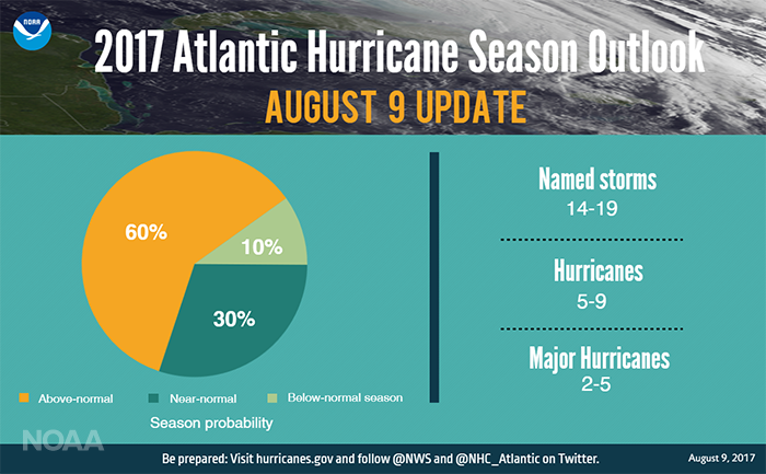
Gerry Bell – NOAA’s 2017 Atlantic hurricane season outlook issued in early August indicated that an above-normal hurricane season was likely. It also indicated that the season could be extremely active (ACE ≥ 165% of the median) and the strongest since 2010. The outlook reflected predictions for a set of conditions to be in place during August-October which are known to produce active seasons. The factors behind the outlook will be discussed and compared with observations.
***Any opinions, findings, and conclusions or recommendations expressed during the webinars do not necessarily reflect the views of the National Oceanic and Atmospheric Administration.
