

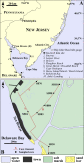
 New research by Daria Nikitina et al. and supported by CPO’s CVP program was published in the journal Estuarine, Coastal and Shelf Science. The research examined relative sea level (RSL) rise in the Delaware Bay in a reconstruction spanning 200 BCE to 1800 CE. The study used high-resolution surveying methods and radiocarbon dating to produce new index points for sea-level, and used these new points in conjunction with an existing set to determine the rate of relative sea level rise during the study period.
The authors concluded that the mean RSL rise rate was 1.25 ± 0.27 mm/yr, and confirmed that the mid-Atlantic is the focal point of subsidence due to forebulge collapse. This process is part of glacial isostatic adjustment – as land under the former Laurentide sheet recovers (mostly in Canada, New England, and Alaska), peripheral land (in the mid-Atlantic) subsides, contributing to relative sea level rise.
Abstract:
We produced eight new sea-level index points that reconstruct a ∼2.5 m relative sea-level (RSL) rise at Sea Breeze in the Delaware Bay from ∼200 BCE to 1800 CE. The precision of our reconstruction improved upon existing data by using high-resolution surveying methods, AMS radiocarbon dating of in-situ plant macrofossils collected immediately above the basal contact between pre-Holocene sand and salt-marsh sediments, foraminifera as sea-level indicators, and by accounting for tidal range changes through time. Our new data were combined with a database of 65 sea-level index points available for the Delaware Bay to estimate the rate of RSL rise in the upper (1.26 ± 0.33 mm/yr) and lower bay (1.30 ± 0.36 mm/yr) using a spatial-temporal model. Correction for changes in tidal range through time removed the disparity in rate between the upper and lower Delaware Bay that had previously been postulated. After paleotidal correction, the rates of RSL rise estimated for the Delaware Bay (1.25 ± 0.27 mm/yr) correlate with the ∼1.3 mm/yr rate reported for New Jersey, Maryland, and Virginia, and confirm that the maximal ongoing forebulge collapse along the U.S. Atlantic coast is focused on the mid-Atlantic.
To access the full paper, visit: http://dx.doi.org/10.1016/j.ecss.2015.08.012


