
NIHHIS to be showcased in Chile at WMO & WHO meeting on Integrated Information Systems for Extreme Heat
CPO’s Hunter Jones will attend to build NOAA and NIHHIS international partnership through the Global Heat Health Information Network.

Advancing scientific understanding of climate, improving society’s ability to plan and respond
Advancing scientific understanding of climate, improving society’s ability to plan and respond
CPO’s Hunter Jones will attend to build NOAA and NIHHIS international partnership through the Global Heat Health Information Network.
Citizen scientists will take to the streets during the hottest days this summer to map hot spots in ten different U.S. cities. The campaign is part of a NOAA-funded project to map places where buildings, asphalt, and other parts of urban environments can amplify high temperatures, putting people at heightened risk of heat illness during extreme heat events.
Citizen Scientists Take to the Streets to Map the Hottest Places in Ten U.S. Cities Read More »
Community organizers in eight U.S. cities have been offered support for UHI mapping campaigns through the National Integrated Heat Health Information System (NIHHIS) and CPO’s Communication, Education, and Engagement Division.
Eight cities slated to run Urban Heat Island mapping campaigns in summer 2019 Read More »
NOAA’s Modeling, Analysis, Predictions, and Projections (MAPP) Program is funding nine new CMIP6 projects (14 grants, three other awards) including $2.1 million over the first year and $5.24 million over the three years of the projects. The Coupled Model Intercomparison Project (CMIP) initiative offers a coordinated community-wide opportunity for model intercomparison, benchmarking, and improvement. The
Addressing Key Issues in CMIP6-era Earth System Models Read More »
In order to address gaps in the understanding, monitoring, and prediction of drought and improve our Nation’s ability to prepare for impacts, NOAA’s Modeling, Analysis, Predictions, and Projections (MAPP) program — in partnership with the National Integrated Drought Information System (NIDIS) — is funding 12 new three-year projects. These competitively-funded projects involve $4.2 million in
Advancing Drought Understanding, Monitoring and Prediction Read More »
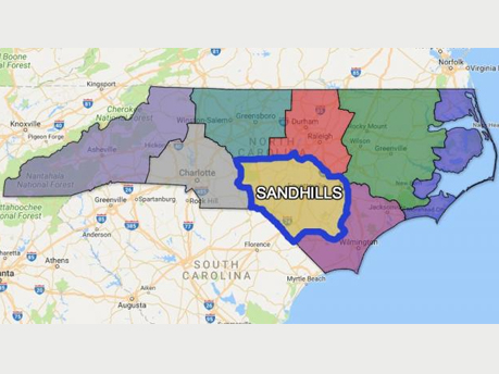
Residents of the Carolinas are familiar with hot summers, but in some areas excessive heat events bring a higher risk for heat-related illness—and even death. A new tool can help local communities get ahead of heat events so they can reduce risk for their residents.
A new set of visualizations and analytical tools to understand, prepare for, and respond to extreme heat and its human health impacts (including economic impacts), has been prepared as an ESRI Story Map, developed in cooperation with NOAA and the NIHHIS Interagency Working Group. The story map includes a number of powerful tools which can also be used as stand-alone analytical web apps. The collaboration will continue, and the tools will be refined over time. The story map will be unveiled officially at the upcoming GEO Plenary in Washington DC, the week of 23 October 2017, and we encourage any and all with interest in climate and health to attend the open sessions and side meetings on Monday and Tuesday of that week – particularly the GEO Health Community of Practice on Tuesday afternoon. For more information on the GEO plenary, visit: http://www.earthobservations.org/geo14.php

Dr. Rick Spinrad, NOAA’s Chief Scientist, addressed participants of the United Nations Framework Convention on Climate Change (UNFCCC) Conference of the Parties (COP) 21 and international viewers in a video presented at the US Center. The session, Healthy People, Healthy Planet: US Programs and Partnerships for Health Resilience was hosted by the Department of State and involved EPA and HHS. In his address, Dr. Spinrad underscored the importance of robust, sustained integrated information systems (IISes) for providing environmental information that spans the weather-climate continuum and supports resilience to climate and health challenges faced in the 21st century and beyond. These IISes not only provide “the right information at the right scales, far enough in advance, along with the right tools” for decision-makers, but also serve as “gateways for improving our research, observations, and prediction capabilities”. Dr. Spinradhighlighted the National Integrated Heat Health Information System (NIHHIS), which is being developed to integrate NOAA’s advancements in observing, understanding, and modeling the Earth system with societal needs for resilience to extreme heat – not only with US partners such as the CDC, but also with international partners including India and Germany. Additionally, Dr Spinrad called out the pilot Cholera Integrated Information System in Bangladesh, which NOAA is developing cooperatively with the World Health Organization (WHO) to support development goals.

The National Integrated Heat Health Information System (NIHHIS) – a NOAA-CDC collaboration that facilitates an integrated approach to extreme heat risk reduction by providing a suite of decision support services to prevent heat related illness and death – is launching its web presence on Monday, May 23, 2016. The NIHHIS portal will serve as the nexus for heat-health information from NOAA, CDC, FEMA, DOD, OSHA, SAMHSA, ASPR, NIH, EPA, and others, and will point decision makers to case studies, tools, trainings, reports, and other resources that inform decisions and reduce heat-related risk.
National Integrated Heat Health Information System (NIHHIS) Web Launch: May 23, 2016 Read More »

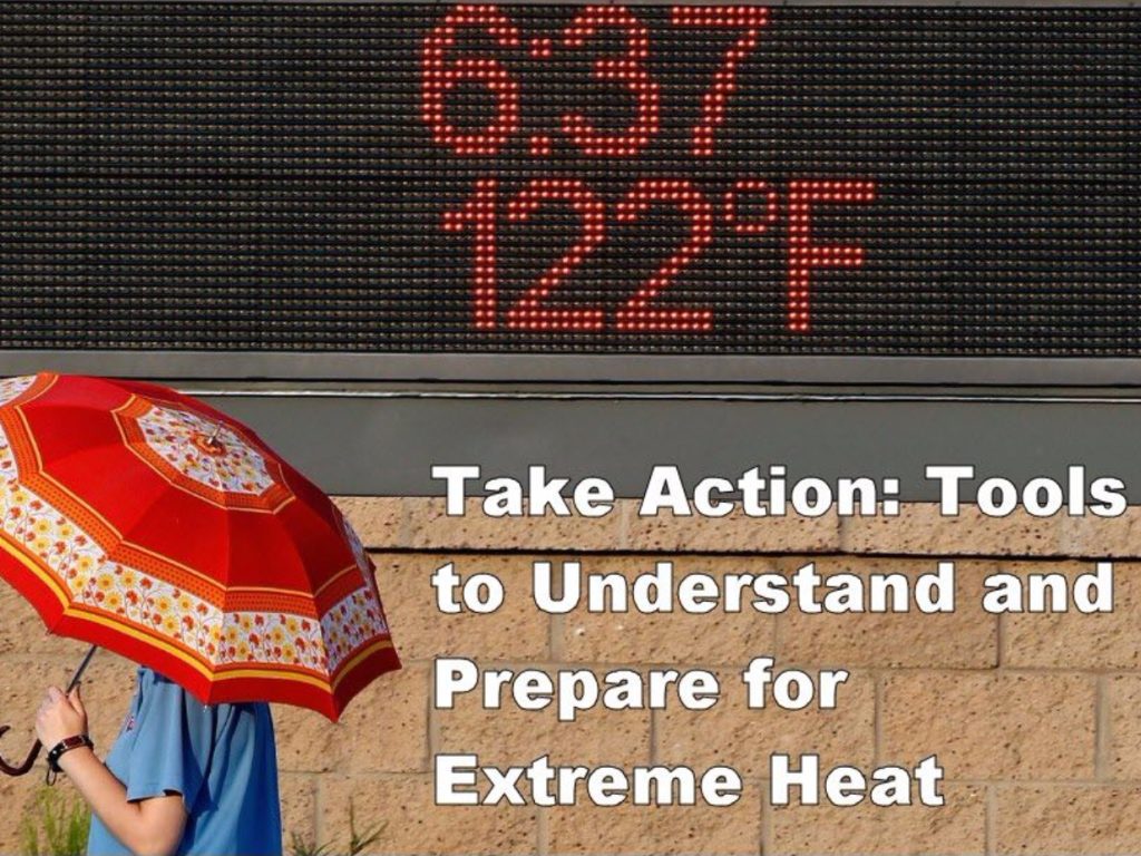
PHOENIX — The southwestern U.S. is about to feel the wrath of a punishing heat wave that includes a forecast of 120 degrees (48.8 Celsius) in Phoenix — a temperature not seen in the desert city in more than 20 years.
The broiling temperatures will also be felt in Las Vegas and Southern California, creating a public health hazard. Rising temps are being closely watched by everyone from airline pilots and emergency room doctors to power grid managers and mountain cities unaccustomed to heat waves.
Even cities accustomed to dealing with 110-degree (43-Celsius) days are grappling with the new problems that arise from 120 degrees (48.8 Celsius).
WaPo: Heat wave creates health hazard in southwestern US Read More »