NIHHIS and NOAA Environmental VizLab Collaborate on Urban Heat Island App
The app provides easy access to data from the NOAA urban heat island mapping campaigns for researchers, government offices, and other users.
Advancing scientific understanding of climate, improving society’s ability to plan and respond
The app provides easy access to data from the NOAA urban heat island mapping campaigns for researchers, government offices, and other users.
To learn where action is needed to protect vulnerable populations now and in the future, CPO’s National Integrated Heat Health Information System (NIHHIS) and partners are launching new community-led campaigns that will map the hottest parts of cities in 11 states across the country this summer. The communities include Albuquerque, New Mexico; Atlanta; New York City; Charleston, South Carolina; Kansas City, Missouri; Raleigh & Durham, North Carolina; San Diego; San Francisco; and parts of New Jersey, Indiana, Massachusetts, and Virginia.
The National Integrated Heat Health Information System (NIHHIS) Heat Health and Social Vulnerability tool will be demonstrated as part of the American Public Health Association (APHA) Town Hall in Philadelphia, PA on 3 November 2019. At the event, this NIHHIS application, which was developed in partnership with Esri, CDC, and NOAA, will be used as part of a scenario-based demonstration allowing attendees to learn how to apply downscaled climate projections and census-tract level social vulnerability information to understand where at-risk populations may reside, and specifically what risk factors can be targeted with interventions.
Abstracts due 2 December 2020
18th Annual Climate Prediction Applications Science Workshop (CPASW) – April 14-16, 2020
Phoenix, Arizona
www.cpasw2020.com
Integrated theme: “Providing Services for the Cascading Effects of Intensifying Heat in a Rapidly Growing Region”
The 18th Annual Climate Prediction Applications Science Workshop (CPASW) will bring together a diverse community to share developments in research and application of weather and climate information for societal decision-making. Participants will include researchers, service producers, resource managers, planners, practitioners, social scientists, and others making weather and climate-sensitive decisions. NOAA’s National Weather Service Climate Services Branch, Arizona State University, the Arizona State Climate Office, and many climate services partners are collaborating in the organization of the 2020 CPASW.
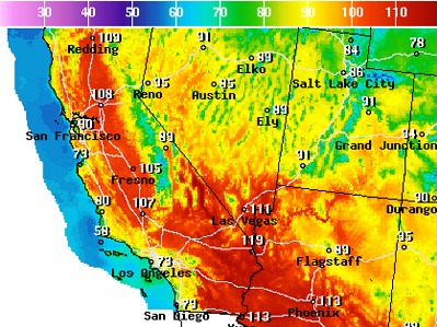
PHOENIX — The southwestern U.S. is about to feel the wrath of a punishing heat wave that includes a forecast of 120 degrees (48.8 Celsius) in Phoenix — a temperature not seen in the desert city in more than 20 years.
The broiling temperatures will also be felt in Las Vegas and Southern California, creating a public health hazard. Rising temps are being closely watched by everyone from airline pilots and emergency room doctors to power grid managers and mountain cities unaccustomed to heat waves.
Even cities accustomed to dealing with 110-degree (43-Celsius) days are grappling with the new problems that arise from 120 degrees (48.8 Celsius).
Firefighters labored in scorching heat Sunday against five separate brush fires across Southern California as forecasters warned of more triple-digit temperatures in inland communities.
The punishing heat wave broke records on Sunday in Lancaster, Palmdale and Sandberg, which saw highs of 108, 108 and 99 degrees, respectively. With a dry, high-pressure system parked over the Southwest, temperatures are expected to keep climbing through midweek, according to the National Weather Service.
A brutal heat wave is expected to scorch the southwestern U.S. this week, with some cities likely to see all-time record high temperatures.
The National Weather Service (NWS) said this will likely be one of the most intense heat waves seen in many years across desert Southwest, including parts of California, Arizona, Nevada, and Utah.
High temperatures could climb well above 110 degrees each day for the next week across the area. Many desert locations, including Tucson and Phoenix, could reach the 120-degrees Fahrenheit mark on Tuesday or Wednesday, followed by a slow decline in temperatures in days to come.
Many outdoor workers get uncomfortably warm during the hot days of summer. As employers are responsible for providing a safe workplace, they need to know when uncomfortable becomes unhealthy.
Predictions for the summer of 2017 show most of the contiguous United States has elevated chances for warmer-than-average temperatures. The summer outlook map and other forecasts in this Web app can help outdoor workers and their supervisors understand heat hazards, keep workers safe and productive, and even save lives.
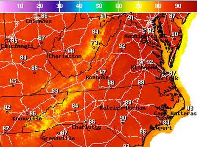
The area’s first heat wave of 2017 is set to start Wednesday. Between Wednesday and Friday, high temperatures should range between 88 and 94 degrees, placing several long-standing records in jeopardy. At the heat wave’s peak intensity Thursday, it will feel as hot as the mid-to-upper 90s factoring in midsummer-like humidity. Throughout the heat wave, temperatures will be about 15 degrees above normal.
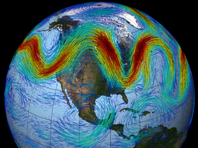
“The idea is that climate change doesn’t merely increase the overall likelihood of heat waves, say, or the volume of rainfall — it also changes the flow of weather itself. By altering massive planet-scale air patterns like the jet stream (pictured above), which flows in waves from west to east in the Northern Hemisphere, a warming planet causes our weather to become more stuck in place. This means that a given weather pattern, whatever it may be, may persist for longer, thus driving extreme droughts, heat waves, downpours and more.”