
Every year, the U.S. Census Bureau hosts and facilitates 12-week product development cycles, or “sprints,” that pull together innovators from across government, industry, and communities to work collaboratively on addressing a challenge or problem. Called The Opportunity Project (TOP), the aim is to build data-powered solutions that help people find, understand, and integrate the federal government’s open data into products that provide value and help solve important problems.
This year, the Census Bureau has selected a problem statement submitted jointly by NOAA’s Chief Data Information Officer Tony LaVoi and CPO/Communication, Education, and Engagement (CEE) Division Chief David Herring. Titled “Tackling the Climate Crisis,” the challenge is to develop accessible, easy-to-use tools to assist local governments in identifying and integrating locally relevant federal datasets into their own tailor-made geospatial information systems to support the development of climate resilience plans.
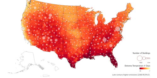
Climate change-driven extreme events and changed patterns of temperature and precipitation are causing cascading problems in our nation’s communities. As the associated frequency, severity, and costs increase, so, too, does the risk facing Americans, especially those most vulnerable to climate impacts, such as poor, underserved, and disadvantaged populations. Some of the greatest climate-related hazards include extreme heat, drought, wildfires, severe storms and very heavy precipitation, sea level rise and stronger storm surges, and poor air quality. Unfortunately, the pace and scale of climate-related impacts are generally outpacing our nation’s response.
To guide and inform their long-term planning and make climate science-informed decisions, local decision makers need data from all levels of government at their fingertips. They need to be able to customize geospatial information in locally tailored maps, visuals, and text to help them understand, visualize, communicate about, and address their local climate-related risks and opportunities.
This TOP sprint challenges participants to create different approaches to improve local decision-making and federal capacity to support state and local-level priorities, so that climate resilience plans may be enacted efficiently in more communities around the nation. This includes easy-to-use geospatial information tools to help local governments identify and integrate relevant federal data together with their own state and local data to help guide and inform their deliberations. As such, this TOP sprint challenge aligns well with NOAA CPO’s nascent Climate-Smart Communities Initiative (CSCI) that is now being planned for launch in FY22.
For more information about TOP, contact either of NOAA’s two points of contact: David Herring, CEE Division Chief, or Kim Valentine, Action NOAA Geospatial Information Officer.


